|
|
|
|
|
|
|
|
|
Research Notes 2023
| December 2023 - Widecombe | ||||||||||||
| 1)
Hameldon Cross - (SX70426/80115)
Information about the Hameldon Cross can be found on our Dartmoor Crosses website.
|
||||||||||||
| September 2023 - Postbridge | ||||||||||||
| 1)
Whiteslade (Snaily) House - (SX6606/7629)
Whiteslade House was originally a
medieval farmstead with two ground floor rooms, one of which had a nice
fireplace, with cupboard recesses each side. There were at least
two outbuildings beside the house. Records show that the house was
occupied by George Stook, in 1813, and by the reverend John White in
1839. The most recent inhabitants, at some point in the late
1800's, were two elderly spinsters. However, it was noticed by
their neighbours that these spinsters never seemed to go shopping to
provide themselves with food and other everyday essentials. This
gave rise to much speculation and gossip between the locals, with a
suspicion of witchcraft constantly coming to mind. In the end,
curiosity got the better of the group and they determined to find out
exactly what was going on in the house and how the spinsters managed to
live without the apparent purchase of food. Eventually, a small
group of neighbours managed to gain entry into the house, whereupon they
found a row of large bottles filled with black slugs preserved in
salt! These apparently formed the main part of their diet, which
were supplemented by a few vegetables grown in their garden. With their secret now uncovered, the two spinsters were so
full of shame and embarrassment that they pined away and died. The
house subsequently became known as 'Snaily House', but it was never
occupied again and has since deteriorated so that all that now exists
are the traces of the walls just above ground level. Unfortunately
we were unable to visit the house on our walk as the whole area around
it has been fenced off and is not open for public access. (Source:
Eric Hemery - 'High Dartmoor', pages 556-557). 2) Riddon Ridge Incised Cross - (SX66641/76673) Information about the Riddon Ridge Incised Cross can be found on our Dartmoor Crosses website. 3) Arthur's Stone - (SX6692/7873) Arthur's Stone is located on the left bank of the Walla Brook at the point where the boundaries of Spitchwick Manor, Widecombe, Lydford and Manaton all meet in one spot. The stone, which had formerly been used as a gatepost, was erected in 1973 by Arthur Routley at the time of the beating of the bounds for Spitchwick Manor. Hence the stone was named after man who erected it. When initially erected the stone was blank but a round bronze plaque, of four inches in diameter, was added to each of three faces at the time of the 1995 beating the bounds. These plaques show an abbreviation for each area represented: WID - Widecombe Parish (East facing); LYD - Lydford Parish (West facing); Spitchwick Manor SJVS (Stephen John Valentine Simpson - Lord of Spitchwick Manor - South facing). There doesn't appear to be the expected plaque on the north face for the Parish of Manaton. (Sources: Dave Brewer - 'Dartmoor Boundary Markers', pages 77-78 and the Dartmoor Explorations website (Under the heading of Cator Bounds on 29/7/2021)). Note: On page 77 of his book, Dartmoor Boundary Markers, Dave Brewer gives the Grid Reference of Arthur's Stone as SX6715/7720. This places it about a mile further downstream on the Walla Brook. I think he has got it confused with another boundary stone that has been sited in this place for many more years and is marked on the current Ordnance Survey map. We were intending to visit this other stone on the walk, but the ground was too wet and boggy for us to be able to reach it on the day.
|
||||||||||||
| August 2023 - Willsworthy | ||||||||||||
|
1)
Willsworthy Military Firing Range - Abandoned Target Tramways at
Reddaford Farm (centres at SX5377/8316 & SX5403/8316) The Willsworthy Military Firing Range
complex was established in the early 1900's by the War Office. Of its
earliest developments were two target tramways east of the now ruinous
Reddaford Farm: a holding that had been purchased from the
Calmady-Hamlyn estate in 1905. In 'High Dartmoor' Eric Hemery only
describes the nearer tramway. He writes of a walled pit to house the
winding gear that moved the target and the presence of a cable drum that
was fast decaying back in his time and probably now disappeared
altogether. Also, an observation post nearby where from, by a series of
iron rods, the signal to 'FIRE' could be raised or lowered as required.
However, he does not mention the second tramway, 330 yards to the
north-east, which GOBS weren't able to look for when visiting in June
2021 due to unfavourable ground with dense gorse and other undergrowth
in the area. The tramway nearest the farm runs from SX53773
83248 to SX53748 83101, commencing inside the eastern enclosure
wall, which it breaches to recede from in a straight line, firstly
alongside a cornditch (according to Hemery) before moving away from the
walls. The furthest tramway runs from SX54022 83411 to SX54018 83247,
higher up within the newtake. Both tramways descend towards the south
and in the open are set below low rivetted walls on their western side
to offer the target trolleys protection whilst firing was taking place.
It is thought that most of the stone used for this purpose may have been
taken from the former farm buildings. Concrete block bunkers have been
constructed at the ends of each tramway for operating personnel to
communicate from and control various items such as winding gear. In the
turf near each bunker are rusting counter-balanced shafts which have
been attributed to target hoist systems. Rusting rails, at a gauge of
two feet, and metal sleepers are in situ the full length of the tramway
and visible in places where they have not yet become overgrown. Of the bunkers the one at the northern
terminus of the nearer tramway is close to a step stile. Within are the
remains of what appears to be part of a communication system. At the
southern terminus the bunker doesn’t appear to have any remaining
communications electrics but does have a recess, which presumably housed
the system historically. On the furthest tramway, the northern
terminus bunker has collapsed, whereas the bunker at the southern
terminus is in better condition and contains an alcove for a telephone,
but there is no trace of the wires or capstans which would have been
used to move the target trolleys on either tramway. It is possible that both fixed and moving
targets were employed. The firing position(s) look likely to have been
from across the Mine Leat in what is known today as Willsworthy Camp.
Nothing has been uncovered to explain how these target tramways were
actually operated. There is evidence of the alignment of two
other abandoned target tramways lying on the crest and gently sloping SW
flank of White Hill. There is a further article on the lower
tramway, written as a result of our walk in the area in June
2021. (Sources:
Eric Hemery - 'High Dartmoor', page 989, Tom Greeves and Dartmoor
Explorations).
|
||||||||||||
| June 2023 - Yelverton | ||||||||||||
|
1) Horrabridge War Memorial Cross - (SX51226/69696) Information about the Horrabridge War Memorial Cross can be found on our Dartmoor Crosses website. 2) Horrabridge Incised Cross - (SX51331/69933) Information about the Horrabridge Incised Cross can be found on our Dartmoor Crosses website. 3) Boundary Stone - Knowle Down - (SX52495/69852) Standing close to a wall beside the
footpath, that runs along the north-west edge of Knowle Down, is a
small, square boundary stone. This stone is engraved with 'K D' on its
eastern One of the fields bordering Knowle Down is still referred to as The Fillace, which is obviously linked to the former name of that part of the down. It is thought that the name 'Fillace' is derived from 'Filacer', which is defined in the Chambers Dictionary as 'An officer of the English Court of Common Pleas'. A Filacer would have been responsible for filing original writs on which he made out the process, which I understand were documents confirming ownership. (Source: Dave Brewer's 'Dartmoor Boundary Markers', pages 192-3). 4) Walkhampton War Memorial Cross - (SX53319/69673) Information about the Walkhampton War Memorial Cross can be found on our Dartmoor Crosses website.
|
||||||||||||
| May 2023 (Short Walk) - Shipley Bridge | ||||||||||||
|
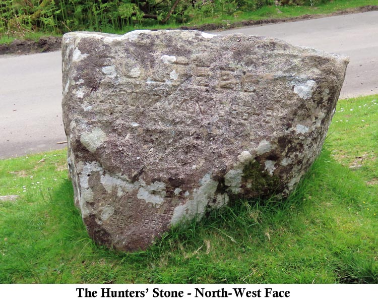
1) Hunters' Stone - (SX68148/63182)
The one name that appears to be missing is that of Francis Meynell (1821-1870), who was born in Derbyshire, served in the Royal Navy and later retired to Devon. Francis used to like his horse riding, along with his young daughter, Mary ('Little Lily'), and later became Master of the local Hunt. Unfortunately, Mary died very young with many Dartmoor references claiming that she died of injuries resulting from a fall from her horse. In actual fact she died in 1863, aged 4 years old, after suffering for a period from Tonsillitis and Laryngitis. More details of the Meynell family and Little Lily, in particular, can be found on our 2014 Research Webpage, as a result of our February walk from that year. (Source: Eric Hemery's High Dartmoor, page 329).
2) River Avon Bridge Supports (possible) - (SX68197/64326) In doing some research for items of interest when planning the walk, I came across a reference, on the Dartefacts Website (www.dartefacts.co.uk), to a 'Ruined Building' at Long-a-Traw on the banks of the River Avon. I made a note of the Grid Reference and decided to check it out on the walk. Although at first glance it does look like a small section of the corner of a building, I'm now certain that it wasn't a building at all. Although we were not able to cross the river at this point to get a better look, a similar structure could be seen on the opposite bank of the river and adjacent to the structure on our bank. It then became clear that the two were supports for either a bridge or pipeline across the river at this point.
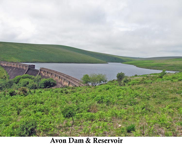
3) Avon Reservoir - (SX6789/6520)
|
||||||||||||