|
|
|
|
|
|
|
|
|
Research Notes 2016
| December 2016 - Hemsworthy Gate |
|
1) Natsworthy Holed Gatepost - (SX7212/8011)
2) Kitty Jay's Grave - (SX7324/7990)
Whilst at the farm she started to attract the attention of the Farmer's son and, in due course, the inevitable happened and she became pregnant by him. As were the ethics of the day, she was cast out from the farm and disowned by everyone who knew her. Eventually, she could stand no more and committed suicide by hanging herself in the barn at Canna Farm, although other versions say that she drowned herself in the river. Whichever, the custom at the time dictated that suicides could not have a religious burial, in fact they were normally buried at a point where a number of parishes meet, or at a crossroads. The reason for this was that when the soul rose from the body it would get confused about which route to take and wouldn't then return to bring bad luck back to the place where the suicide occurred. At some time during the 19th century, Mr James Bryant, of Hedge Barton Farm, was doing some work in the area and came across this unmarked grave. He had the grave opened and the contents examined, which confirmed that it was the body of a young woman. After examination, the body was re-interred and an earth mound set up around it reinforced by rocks around the edge. It is said that since the body has been re-interred it has never been without a fresh supply of flowers, although no-one seems to know who is responsible for placing them at the grave. Nowadays, the grave also attracts a number of offerings, such as coins, pebbles, shells and candles, from the innumerable people who visit the site. (Source: Eric Hemery's 'High Dartmoor', pages 725/6 & Legendary Dartmoor Website).
|
| November 2016 - Bennet's Cross |
|
1) East Vitifer Tin Mine - (SX708/823) Worked from 1845-1887 and again between 1912-1913. In the woods near Coombe, on the steep north-east slopes of Shapley Tor, will be found the overgrown remnants of stone walls and dressing floors, and the portals of two adits. On the downs above are the remains of shafts, a wheel pit and a flooded reservoir. (Source: Butler, Crossing, Harris, Hemery & Newman). 2) Fishes Stone No.3 - (SX7143/8086) Information on this stone has been added to the entry for the other two Fishes Stones which we visited in December 2014. Please click for the Link to this webpage. 3) RAF Memorial - Hameldown - (SX7128/8070)
With the exception of
the pilot, who died the following day of his injuries, the crew were
killed outright - P/O The Hon R. D. Wilson (pilot), Sgts R. L. A. Ellis
(co-pilot/navigator), C. J. Lyon (wireless operator) and R. Brames (rear
gunner). A lot of the wreckage was towed from the crash site by
tractor driven by local girl Dorothy Miners, who was in her late teens
at the time. In the years
following the accident, the pilot's mother arranged for a large
inscribed standing stone to be erected approximately 50 metres NNW of
the crash site: no wreckage is visible. The current plaque was affixed
when the stone was cleaned in 1991. (Source:
Graham Lewis - 'Wings Over Dartmoor'). 4) Challacombe Down Stone Row - (SX6897/8084) A bulky,
transverse, triangular-shaped stone, standing over 2 metres in
height and visible across the valley from Grimspound, marks the southern
end of a rare example of a triple stone row that descends through the
heather on the northern ridge of Challacombe Down for approximately 156
metres towards Birch Tor. This row, one of the loftiest on the moor, was
first recorded by John Prideaux in 1828 when, according to Butler, most
of its stones were found to be standing in their current positions
although Crossing remarks that they were fallen at this date. A few were
re-erected by Burnard and Baring-Gould in 1893, one being probably
set incorrectly across the middle row near its downhill end. The restorers
also re-erected, in a haphazard position alongside this, some fourteen
stones which make for a very strange arrangement. These 'finally'
positioned stones were probably the original members of the rows' northern
ends, dragged to where they were found by the 'Old Men' (who were always
respectful of antiquities in the vicinity of their workings) when
excavating Chaw Gully. Unlike most Dartmoor stone rows no trace of barrow
or cairn has been uncovered, so it is most likely that it was destroyed
when the workings were being dug. (Source:
Butler, Crossing, Hemery, Pettit, Rowe & Worth).
|
| October 2016 - Whiteworks |
|
1) Whealam Bottom Cross (SX6132/6949) Information about the Whealam Bottom incised cross can be found on our Dartmoor Crosses website. (Source: Dartmoor Crosses website). 2) Northmore's Cross - Hand Hill (Grid reference witheld) Information about Northmore's Cross can be found on our Dartmoor Crosses website. However, at some time between March 2012 and October 2016 the cross was destroyed, leaving only a very short length of the shaft protruding from the top of the rock. As of December 2019, a replacement cross has been made and now sits proudly on top of the rock again. (Source: Maurice). 3) Phillpott's Cave (SX6303/6728) It is suggested that Philpott's Cave, just a short way above the eastern bank of the Blacklane Brook, is large enough to shelter 3 people. The cave is set amongst some large boulders and covered by a large slab which measures 35 feet by 13 feet. The natural gaps around the cave have been blocked up with a number of smaller stones to leave just the north-facing entrance. The earliest known use of the cave was by a John Spencer, moorman, who used to maintain the culverts and causeways in the area and would cook and eat his meals here and sleep in the cave during the summer months, rather than making the long trek home each day. It was Eden Phillpotts, the Author, who adopted the cave at the beginning of the 20th Century. He cleaned it out, blocked up the gaps with stones and turf and equipped it with emergency rations of preserved food and whisky - of which sadly none remains today. (Source: Eric Hemery's 'High Dartmoor', page 275). 4) Grant's Pot (SX6297/6706) Grant's Pot was found in 1953 by Scoutmaster, John Grant, and the Senior Scouts of the 4th Teignmouth Group. The popular belief that it is a miner's adit is incorrect, as the pot is just a small underground cavern. John Grant had a lot of experience in pot-holing and caving gained in the Pennines and he put this to good use in exploring this underground cave. On discovery, he thought it would make a good site for a letterbox but it wasn't until another 19 years had elapsed that he and a group of pupils of the Dawlish Secondary School, where he was employed as a senior teacher, arranged for the letterbox to be sited within the cave. This letterbox became the 14th entry of the original 15 letterboxes put out on the moor. (Source: Legendary Dartmoor Website). 5)
Wollake Mill (SX6291/6693) Well Lake Mill/Wallack Mill, indentified by William Crossing, c. 1889, is mentioned in the Forester’s Accounts for Henry VIII when in 1532 the king’s representative collected rent of 3 pence from Cornwood men, Richard Cole and Richard & William Hele, and again in 1538-9 from Richard Coole and Thomas Hele, for a mill and two acres adjoining in the Forest of Dartmoor, which would equate to the curved enclosure in which the ruin is sited. Worth questioned Crossing’s claims that it was a tin mill or place for crushing ore because of its size and apparent lack of a leat or water course, and instead placed the mill further upstream on the right bank of Ducks’ Pool Stream at its confluence with the Wollake, but Hemery agrees with Crossing in that there is evidence of a traceable leat lower down. Jeremy Butler has identified this ruined tinner’s building, in Vol 4 of his Dartmoor Atlas of Antiquities, as TB8 in the text associated with his Map 55, but the absence of such numbering on the relevant map creates a considerable amount of confusion. (Source: Butler, Crossing, Hemery & Hansford Worth). 6) 'A' Head Rock (SX6205/6727)
7) Broad Rock (SX6185/6724)
|
| September 2016 - Shipley Bridge |
|
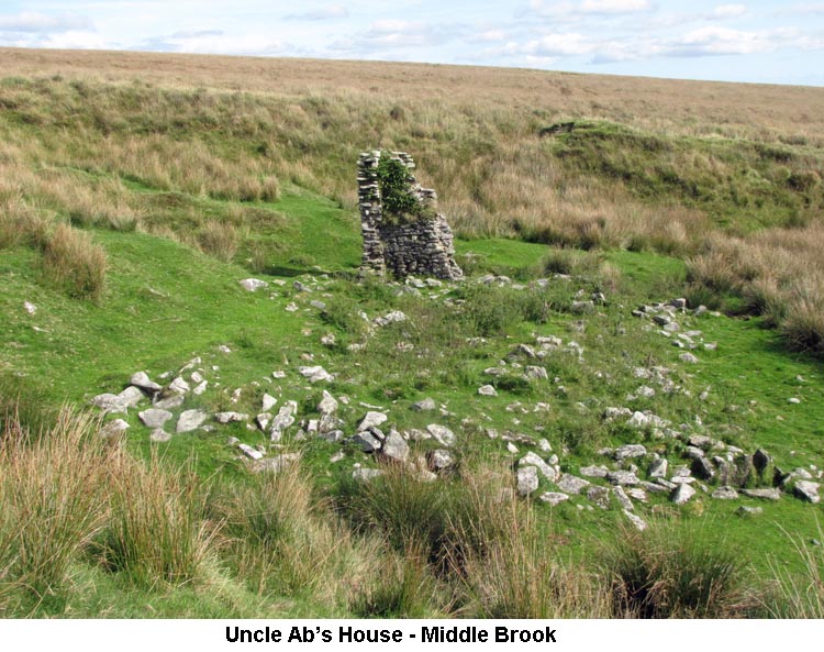
1) Three Barrows Cross (SX6516/6268) - (Update on October 2014 Notes) Further to our previous visit to Three Barrows, in October 2014, a tip-off has pointed us to the site of what is thought to be the portion of cross that is all that remains of the original Hobajohn's Cross, in clitter near the north western cairn of Three Barrows. This stone represents the head and one arm of the cross. It seems this cross was taken from the spot where the current Hobajohn's Cross is sited (SX/6551/6047) and re-erected at Three Barrows. This cross was erected, along with three others in the mid-16th Century, on behalf of Sir William Petre to mark the boundary of his Manor of Brent. The three other crosses were sited at Lower Huntingdon Corner, Western Whittaburrow and Buckland Ford, although the latter is now missing. Sir William was one of the signatories to the dissolution of the Buckfast Abbey in 1539, when it was valued at the sum of £464 11s 2d. He then promptly went out and bought the land belonging to the former Abbey and incorporated it into his estate. (Source: William Crossing's 'The Ancient Stone Crosses of Dartmoor', page 12 & Dartmoor Crosses website). 2) Uncle Ab's House (SX6565/6394)
3) Zeal Tor Tramway (SX6492/6603 to SX6802/6291) History After
acquiring rights from the Duchy of Cornwall in 1846 - to cut, manufacture
and vend peat and peat charcoal - Captain Leyson Hopkin Davy and William
Wilkins of Totnes established the South Brent peat and peat charcoal works
(Shipley Bridge Naptha Co) at Shipley Bridge. In order to transport the
raw peat extracted from turf ties situated at Red Lake Head mires (aka the
Blackwood Ties - a particularly peat rich area) a three miles† long
horse drawn tramway of five foot gauge was constructed in 1847 comprised
of wooden rails fastened to granite ‘sleepers’. Horses
would tow empty wagons to the top terminus (Red Lake mires), where
earthwork remains of a loading bay and peat press can be found, whilst
wagons loaded with compressed material would go back to the works. The
return, starting from Western White Barrow (a location from the turf ties
to which initial horse haulage would surely be required), occurred under
the influence of gravity and was controlled by a brakeman. From an
acquaintance of William Crossing came stories of brakes failing to
function in frosty weather resulting in the occasional loaded wagon
precipitating through the roof of the works buildings at the south-eastern
foot of Zeal Hill. The
men, mostly from Brent, who worked the Red Lake turf ties, stayed on the
moor during the week in a dwelling they had constructed across the centre
of Western White Barrow. These fellows were responsible for destroying
Petre’s Cross when utilising it as a chimney lintel. Their weekly diet
would be supplemented by rabbits poached from nearby Huntingdon Warren
which was possibly reason enough for the warreners to build a small
watchman’s shelter into the western side of the hill overlooking the
River Avon below Broad Falls. Uncle
Ab’s House (aka Petre’s Pits House), at the upper end of Petre’s
Pits Bottom on the Middle Brook, was where tramway horses were stabled. In
1954 the entire shell of the building, with inscribed door lintel “GB
1809” (CB 1809?), still stood†. It is interesting to note that this
door lintel predated the tramway by thirty-eight years, begging an
explanation as to what purpose the building was originally erected. It is
known that tin steaming had taken place at an earlier time along the Bala
Brook and its tributaries. An old 1 inch OS map of the area for the
1900’s shows the track from Corringdon Ball gate extending beyond Uncle
Ab’s House and Knattabarrow to reach Bala Brook Head. However,
with the advent of the rapidly developing gas industry, the 1846 peat
venture was soon killed off and the partnership dissolved in Aug 1850. In
the latter part of the decade, following the company’s failure, the
slate roof of the White Barrow dwelling was removed and the walls largely
demolished with only the west end, containing the chimney, standing to any
height; the cross, minus its arms, being replaced, but upside down on the
cairn. In Walking the
Dartmoor Railways Eric Hemery disputes what other writers have to say
about two separate and subsequent enterprises working the Bala Brook Head
clay pits in 1855 and 1872, he considers that only one was involved; yet
Crossing, writing in Amid Devonia’s Alps of a walk across the area in
1872, described the tram-road as in a ruinous condition, but that the
works buildings at Shipley were part renovated by the Brent Moor Clay
Company and that a Clay Company had started some time previously on Brent
Moor also making use of the works. So we have a
situation where clay was being obtained by the China Clay Co Ltd from Bala
Brook Head (Petre’s Pits) about 1855-1858 with the tramway not utilised.
The clay was washed down in the first instance in open channels to the old
Knattabarrow dries near Glazebrook viaduct‡ (the GWR bridging span at SX
688591). It is recorded that an unsuccessful venture was undertaken around
1836 when an insignificant quantity of clay was extracted from what was
called Knattabarrow Works (now Knattabarrow Pool - aka Petre’s Pits Pool
- SX656644), but no further details of this have been found at the time of
writing. Initially, the
(two) aforementioned open channels left the Bala Brook on its right bank
descending steeply down the hillside to presumably cross both the Middle
and Red Brook tributaries on launders before disappearing underground on
Treeland Down. Soon afterwards the China Clay Co Ltd adopted an improved
process using the buildings of the former naptha company, and channels
were cut on the eastern side of the valley to feed new settling pits at
Shipley. Also, a leat 2¾ miles long was cut from Heng Lake (River Avon)
via the slopes of Eastern Whittabarrow and through Broad Rushes to assist
the process. Clay production would continue intermittently from this area
until cessation during the first third of the twentieth century. Nearly twenty-five
years would pass before the decaying tramway was given a reprieved lease
of life when, in 1872, the Brent Moor Clay Co was formed by Messrs Hill
& Hall. They sought to produce clay on land leased from Lord Petre of
Brent, again at Bala Brook Head and to which a connection was laid from
the old tramway near the existing ¾ mile post into what would be referred
to as Hall’s and Hill’s Pits (aka Petre’s Pits); the section to Red
Lake being abandoned. The tramway only
handled materials; the clay being conveyed through stoneware pipes to
Shipley Works as slurry. The quality of the clay was poor in colour, even
after extensive refining, and only fit for pottery use. Also, because of
its abrasive nature it quickly wore away the pipes that conveyed it. The
later part of the 1870’s saw a marked depression in the china clay
industry and the venture was abandoned by 1880. A third and final
attempt was made to work the clay deposits in Petre’s Pits in 1923,
possibly in association with the Red Lake and Left Lake workings. A new
pipeline was run to the Shipley works and iron rails to a gauge of 2 feet
were laid in the pits on which clay tip wagons built by Hudson of Leeds
ran. With the dissolution of the Red Lake/Left Lake venture in 1933 the
clay industry died on this part of Dartmoor. In 1953 the rusting remains
of three wagons together with some iron rail could still be found†. A
brief attempt to discover whether any of these remains might still be in
situ was made in September 2016, but the area was extremely difficult to
negotiate and the idea abandoned through shortage of time. There are obvious
gaps in the tramway’s history that would be worthy of research: even Dr
Phil Newman has commented on the need for a detailed investigation of the
Brent Moor/Shipley Bridge peat works to compliment work of a similar
nature conducted for North Dartmoor. One can only hope it will happen at
some stage. Observations An intriguing
aspect of this tramway is the existence of two distance marker stones: few
references have been made of them by those who have written with regards
to the old route. Although there is
no clear evidence either way, Eric Hemery asserts that stones were erected
beside the tramway at each ¼ mile to indicate the distance from the Red
Lake mires loading platform to the former works at Shipley. He mentions a
½ mile stone lying on its back southeast of the water divide (though
where exactly he does not make clear) and a ¾ mile stone. However, when
walking the abandoned route, certain aspects of what Hemery alluded to do
not add up; particularly his reference to the ½ mile stone. The ¾ marker is
readily found at SX 6641 6469, but as for the ½ marker there isn’t one.
Instead, a stone engraved 2 miles is located at SX 6602 6490. This stone
was commented on by George Thurlow in his Dartmoor Companion when he found
it difficult to locate in 1983 because it had collapsed into the
track-bed. Fifteen years later he said it was easier to find having been
cleaned and re-erected. Both stones are of
different geological origin with the 2 miles stone exhibiting greater
signs of weathering compared to the ¾ stone on which the characters seem
more etched than carved. What is difficult to understand is why Hemery
should consider datum being measured from the turf ties rather than the
works! Herein is a problem
as it is not known: a) who was responsible for placing the marker stones,
b) whether they were actually located at ¼ mile intervals and, c) how
accurately it would have been done. No matter which way it is worked the
distances indicated by these stones are at odds with measurement. The line
of the old track can be readily followed from just north of Crossways
(where it is bisected by the track-bed of the Red Lake Railway), and with
the exception of a three-tenths of a mile section southeast of Broad
Rushes, to a point alongside the enclosure walls above Avon Filtration
Station. Here, after rising from that facility, a tarmac road descends to
the Hunters’ Stone and connects with the reservoir’s service road. It
is believed this new road cuts across the line of the original tramway,
but the lack of both knowledge and ground evidence for the alignment of
this final stretch to the Shipley works does not help. Considering the
comment previously referenced to William Crossing, the tramway might have
taken a direct line from the enclosure walls or conversely followed the
enclosures before swinging north-east towards the lower terminus. The
route becomes slightly steeper at a point half a mile from the works,
necessitating adequate braking to prevent loaded wagons running out of
control towards the buildings at Shipley. Measuring distance
back from Crossways does not work as the 2 miles stone is about 1 mile (in
fact closer to 1⅛ miles) away whilst the ¾ stone is at
1⅜ miles. However, taking their distances as from Shipley then
placement is closer, but in both cases about ⅛ mile short of where
they should be. The question arises as to whether these two stone are
found where they were originally set. Also, what are the chances of
discovering any others? The lack of similarity between the two known
stones tends to suggest that any suitably shaped piece of granite would
have sufficed for the task thereby making it more challenging to discover
‘missing’ markers. If these distance
markers ever existed, as Hemery implied (and where would you find the
evidence to prove so?), then they have either fallen to be engulfed by
peat or become the spoils of souvenir hunters. Therefore, speculating on
the possibility of quarter mile placement other stones might be found near
the following OS Grid references: ¼ mile - SX 6759 6309, ½ mile - SX
6727 6325, ¾ mile - SX 6714 6364, 1 mile - SX 6711 6405, 1¼ miles - SX
6690 6437, 1½ miles - SX 6659 6459, 2¼ miles - SX 6549 6509, 2½ miles -
SX 6530 6544, 2¾ miles - SX 6509 6577, 3 miles - SX 6487 6612 (this one
less likely). It needs to be born in mind that an error of as much as
⅛ mile might have to be allowed for. (Sources:
‡J Butler, Wm Crossing, H Harris, †E Hemery, Dr P Newman, G Thurlow
& E A Wade). |
| August 2016 - Okehampton Train Station |
|
1) Fitz's Cross
& Well (SX5919/9378)
Information about this Fitz's Cross can be found on our Dartmoor Crosses website. 2) East Mill Tor Target Railway (SX6040/9079) Please see research notes from November 2014 for information on East Mill Tor Target Railway. 3) New Bridge (SX5961/9031) Please see research notes from July 2014 for information on the New Bridge over the Black-a-ven Brook 4) Row Tor Target Railway (SX5927/9109) Please see research notes from July 2014 for information on Row Tor Target Railway. 5) Ten Tors Cross (5878/9285) Information about Ten Tors Cross can be found on our Dartmoor Crosses website.
|
| July 2016 - Wrangaton |
|
1) Spurrell's Cross (SX6591/5997) Information about Spurrell's Cross can be found on our Dartmoor Crosses website. 2) Hobajohn's Cross (SX6551/6047) Please see research notes from October 2014 for information on Hobajohn's Cross. 3) Aircrash Site - Three Barrows (SX6536/6266) Please see updated research notes from October 2014 for information on the Wellington Bomber crash site. 4) Cuckoo Ball - Chambered Tomb (SX6596/5819) It is considered that the Cuckoo Ball burial chamber (circa 3000 to 2000 BC) pre-dates the Bronze Age and was once the finest Dolmen on the moor. The two remaining erect slabs are 6½ feet long and 5⅔ feet high, respectively. It is thought that the chamber was once covered in stones, to form a cairn some 120 feet long with a north/south orientation. This must have been an impressive sight outlined against the sky, when approached from below. In all probability the stones from the cairn were robbed during the building of three hut circles in the vicinity and, much later, the stone wall that now runs past this relic. (Source: Jeremy Butler's 'Dartmoor Atlas of Antiquities - Volume 4', pages 36/7 Eric Hemery's 'High Dartmoor', page 256).
|
| June 2016 - Scorriton |
|
1) Ian Mercer Boundary Stone (SX6782/6865) See Item 4 from the Research notes for September 2015 walk. 2) Nine Stones Boundary Stone (SX6613/6917) This is one of a number of boundary stones on the border of the parishes of Holne and Buckfastleigh. The stone, inscribed with an 'H' for Holne, is set amongst a number of smaller stones beside an old tinner's reservoir. I've not been able to find how it came to acquire the name of 'Nine Stones' and can only assume that it was so named due to there being eight other reasonably sized stones around it. (Source: Maurice). 3) Wellabrook Boundary Stone (SX6645/6857) This tall and slim boundary stone, standing at the head of the Wellabrook Gert, is visible from quite some distance away, weather permitting. It is inscribed with a 'B' for Buckfastleigh and stands on the border of that parish with Dean Prior. (Source: Maurice). 4) Puper's Incised Cross (SX6728/6737) Information about the Puper's Cross can be found on our Dartmoor Crosses website. 5) Crad Hole Ring - Hickaton Hill Settlement (SX6722/6651) This single enclosure is somewhat isolated from the other settlements in the Avon valley and sits at the head of an east facing combe overlooking Brockhill Mires. The outer wall consists of large slabs and boulders. A further line of boulders separates off part of the upper area of the settlement. There would appear to be several entrances to the ring, but the most prominent is on the south-east side, as here the walls curve in slightly towards it. Originally, there were four hut circles within the settlement, of which three appear to have an annexe attached to them. Unfortunately, sometime after the settlement was abandoned quite a lot of the stone has been reused by granite cutters, with the good stone being taken away for re-use and the faulty stones abandoned. (Source: Jeremy Butler's 'Dartmoor Atlas of Antiquities - Volume 4', page 164).
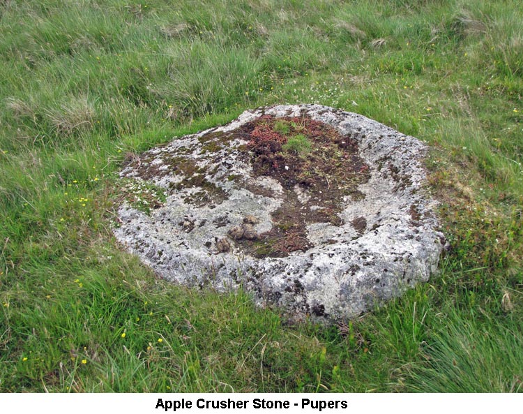
I've not been able to find anything recorded about the stone we found lying beside the track, from Hickaton Hill to Lud Gate, to the south of Pupers. However, it does have a similar appearance to other abandoned stones on the moor which have been identified as Apple Crushing Stones. The Legendary Dartmoor website mentions abandoned Apple Crusher Runner and Base Stones about 300 yards to the north east of this stone. It may well be that the granite in this area is in some way flawed and several attempts were made before the perfect stone was found. (Source: Maurice).
Little Man, also referred to as Kit's Stone, is the smaller of a number of menhirs to be found on Dartmoor. Being placed at the intersection of two moorland tracks, it's purpose was to serve as a Guidestone. One of the tracks ran from Ryder's Hill, through Snowdon, Pupers and Water Oak Corner to Cross Furzes or Dockwell. The other track ran from Lud Gate, Huntingdon Cross and out to the open moor on the Abbot's Way. (Source: Eric Hemery's 'High Dartmoor', page 307).
|
| May 2016 - Prewley Water Treatment Works Road |
|
1) Rattlebrook Railway & Peat Works (SX559/871) The Rattlebrook and Amicombe area was the scene of the largest peat cutting operation on the moor. The peat was cut by the men of Lydford, Sourton and Bridestowe and taken to the peat works on the east side of the Rattlebrook where it was stored for drying. Within the peat works the remains of a large boiler, and an oven door frame, that would have been used to create some heat in the drying process can still be seen. After drying, the peat was loaded onto wagons and taken along the peat railway to Bridestowe. The railway was composed of iron rails which ran for 5 miles, during which it climbed 1,000 feet, and included bridges, cuttings, embankments and the points (SX545/887), which were used to manoeuvre the train around a very tight bend below Corn Ridge. Initially, the trucks were pulled by a team of horses along a gravel track, but these were later replaced by a petrol-driven light locomotive when the rails were in place. The railway was completed in 1879 and ran until 1924. By 1961, the buildings had become unstable and were blown up by the Army at the Duchy's request. In addition to the main railway, where the dried peat was conveyed from the works at Rattlebrook Head down to Bridestowe, there is evidence of some local tramways/railways, which brought the peat down from the ties to the peat works at Rattlebrook Head for drying/processing. The first of which was established by the Dartmoor Peat Company in 1874, whose sale schedule later in the same year included six wagons and iron rails, though the precise location of this system is not recorded. By 1884, two tramroads are known to have existed, with one being led from the ‘Black Peat’ and the other from the ‘Grey Peat’. Tramway 1 (SX 5601/8710 – SX 5663/8678) The most easily recognised of the tramways is probably that described in 1884 as leading from the ‘Black Peat’, although what remains today may be the result of alterations and extensions over the life of the works. However, it was depicted on the 1889 OS 6-inch map having approximately the same course and extent as the evidence today. It survives for most of its course, consisting of an upstanding linear earthwork of on average 7. 5m wide at base and up to approximately 1m high. Its final extent was 850m, and its course ran for 316m ENE from the eastern side of the works up the slopes of Amicombe Hill before heading SE, extending down through the turf ties. Timbers, which supported the iron tram rails, survive in place running along the top of the embankment. These are likely to be survivors of the 20th-century re-use of the tramway. The course of the tramway transects pre-existing turf ties whose evidence clearly runs beneath the embankment. It would appear therefore that the tramway would be extended gradually over recently cut ground as work progressed south, rather than pre-installing the tramway to serve a large area from the start. Had work progressed further south then the tramway certainly would have extended further south. Near the works, the tramway terminated just to the west of the ovens where a large drying shed once stood on the raised ground. Tramway 2 (SX 5614/8715 – SX 5631/8697) A second section of raised linear earthwork which runs parallel with part of tramway 1 and joins at a Y junction, almost certainly supported a tramway. Tramway 3 (SX 5597/8706 – SX 5646/8679) Earthwork fragments of a tramway, which ran from the large building at the works in a south-easterly direction clearly post-dates them all. The course of a tramway is marked in the vicinity of the building following this approximate course on a map of 1884 and described as coming from 'Grey Peat’. Although not present on the 1889 OS 6-inch map, it is clear on that of 1906, where it extends as far to the east as the remains today suggest. The course of a another, shorter tramway, depicted on the 1906 map running between the two existing tramway earthworks, has not survived. (Source: Eric Hemery's 'High Dartmoor', pages 909-910 & Phil Newman: 'Domestic and Industrial Peat Cutting on North-Western Dartmoor'). 2) Ring Rock (Amicombe) (SX5733/8591) Ring Rock is a large squarish rock with two metal rings fixed into the top of the stone. This would have been used by moormen in the olden days to tether their horses whilst working out on the moor. There are several examples of these rocks on the moor which were generally used by tinners but, in this case, might well have been used by the peat cutters working on Amicombe Hill. (Source: Maurice).
|
| April 2016 - B3212 below Sharpitor |
|
1) Devonport Leat - Southern End (SX5501/6838) At this point of the leat on Yennadon Down, the Devonport Leat comes to a dead-end. Here, in the centre of the leat, is a rotary screening device which captures dead leaves and other floating debris before allowing the water to flow down into a vertical pipe which carries it underground to the Dousland Water Treatment Works. After being treated it is piped on to numerous supply points. When full, the screening basket can be lifted by an on-site hoist, swivelled around and emptied of its contents. Any excess water flows through a grille in the base of a building, which resembles a pumping station. Here another screening device draws off any dead leaves and other debris, which flow out of the building into a basket trolley. This trolley can be wheeled away and emptied as and when required. The water then flows through a pipe down the hill towards the reservoir. About halfway down, the pipe ends and gravity forces the water out of the pipe into a spectacular waterfall and it then runs on down the rest of the hillside. This waterfall once worked an electricity generator at the Lodge but since being connected to the mains supply, in 1981, the water now runs under the road and into the reservoir. The leat supplies in the region of 2.9 million gallons of water each day. (Source: Eric Hemery's 'Walking the Dartmoor Waterways', page 19). 2) Burrator Halt Railway Station (SX5499/6794)
The branch line was authorised in 1878 and opened on 11 August 1883, with the general gradient of the line being 1:40 to 1:41. Yelverton was the junction for the line when the halt opened, three other stations had been added to the line in the 1920s, plus Ingra Tor Halt in 1936. King Tor Halt was opened almost on the site of the old Royal Oak Sidings. The freight traffic on the branch line included granite from the rail-served quarries of Swelltor and Foggintor which were closed in 1906. Owned by the Princetown Railway until 1 January 1922, the company then merged with the Great Western Railway (GWR). The line passed to British Railways (Western Region) in 1948 and closed on 3 March 1956. The track was lifted in December 1956. Only the foundations of the station remain, together with the old steps up from the lane and a swing gate. (Source: Wikipedia Internet Site). 3) Longstone Manor (SX5569/6847) Longstone Manor House was once the ancestral home of the Elford family, who were Lords of the Manor and Free Hamlet of Sheepstor, and who lived here until the middle of the eighteenth century. It has been suggested that much of the present building was rebuilt for Walter Elford (circa 1633) and came into the Elford family when John Scudamore's daughter, Johanne, married John Elford. Longstone ceased to be a Manor House in 1748 and passed out of the Elford family. It is recorded as being in the ownership of William Smith in 1750, by which time the property had been downgraded to a farmhouse. It continued to serve this purpose for almost 150 years and subsequently became much reduced in size. As a consequence of the construction of Burrator Reservoir, which had begun in 1893, the farm was abandoned in 1898, having been in the possession of Manesseh Masseh Lopes, Maristow Estate, from 1811. The last tenant who lived at Longstone Farm was Mr George Creber. Following the construction of the reservoir several granite artefacts were recovered from Longstone Manor for safekeeping. These include the date-stones of the house (1633) and windstrew, some doorways and a stone lectern, all of which were re-sited in Wembley Walk, situated near the Burrator Discovery Centre. Other items that have been recorded at Longstone Manor, but which have now disappeared, include two mould stones, a mortar stone, a granite feeding chute and a holed gate hanger stone. Beside the fence around the Manor is an apple mill (apple crusher), surviving evidence that cider was once made at the site. Also nearby is the Windstrew (Threshing Platform), a rare example of a raised stone platform where corn was threshed by hand. There are also a number of granite troughs scattered around the site. Behind the farmhouse and by the water's edge is a cross base, which is believed to have once supported the Lowery Cross, which has now disappeared. The cross base was probably moved to Longstone Manor for safekeeping. (Source: Longstone Manor Signboard & additional website information).
|
| March 2016 - Steps Bridge |
|
1) Wooston Castle (SX7648/8964) The extended Wooston Castle site has been granted the status of a Scheduled Ancient Monument (SAM). The open area we saw today was just the top of the castle - the whole site extends to about 15 acres in total. The Woodlands Trust, together with the National Trust, have now secured grant funding to restore and research the castle site. As well as these two organisations allotting money themselves, further funds have been secured from the Heritage Lottery Fund. The first part of the restoration is the clearance of trees from the top of the castle, of which we saw ample evidence on the walk today. Further clearance will take place shortly, especially to the south of the main castle which will open up a number of deep ditches which are currently screened from sight by large conifers. A certain amount of work has already been undertaken to survey the open area, but it is hoped that further funding can be secured to undertake a comprehensive archaeological survey of the whole site over the next five years. This will include some archaeological digs and some research to see how this castle might be linked to the other castles (Prestonbury & Cranbrook) in the Teign Valley. This is a long-term project which is expected to take five years or more to complete. (Source: Adrian Colston's website).
|
| February 2016 - Postbridge |
| 1)
William Donaghy Stone (SX6399/8006)
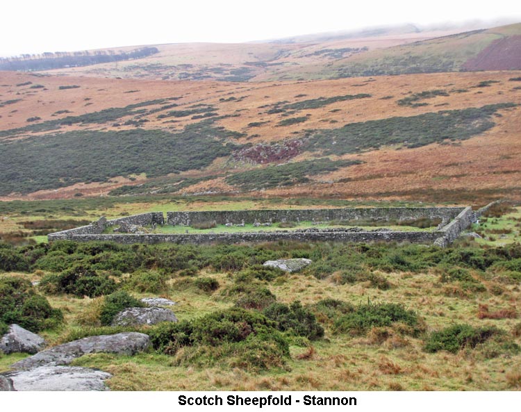
2) Scotch Sheepfold - Stannon (SX644/808)
3) Postbridge (Maggie) Cross (SX6516/7922) Information about the Postbridge Cross can be found on our Dartmoor Crosses website.
|
| January 2016 - Bellever |
|
1) Krapp's Ring (SX644/781) Krapp's Ring is a large settlement pound at the northern end of the wide tract of
unforested ground that runs downhill from Bellever Tor. The raised
bank, containing mostly buried stones, that forms the perimeter wall can be
seen virtually all the way around. The pound encloses an area covering
120 metres by 113 metres, which is approximately 2/3rds
the size of Grimspound. Although the pound originally
contained about 15 hut circles, the remains of only a few these are still
visible today. Several of the huts were excavated by the Dartmoor
Exploration Committee in 1895 and all but one were found to have previously
been 'dug over' and anything of any archaeological value has been lost
forever. However, they were able to excavate one hut that had not
previously been disturbed and found a cooking hole and a hearth within it,
but no other artefacts that might have been of value. (Source:
Jeremy Butler's 'Dartmoor Atlas of Antiquities, Volume Two', pages43/44). 2) Bellever Cist & Stone Row (SX6449/7761)
|