|
|
|
|
|
|
|
|
|
Research Notes 2015
| December 2015 - New Bridge |
|
1) Coffin Stone (SX6773/7330) Information about the Coffin Stone can be found on our Dartmoor Crosses website. (Source: Maurice). 2) Dr Blackall's Drive (SX694/731 to 707/716) Dr. Thomas Blackall came from a very prominent Exeter family in the late 1800's. His father, John, was an eminent and noted doctor, a career which Thomas shared. In 1862 there was a Thomas Blackall serving as the sheriff of the City of Exeter, a place where he spent most of his time. However, he did own Spitchwick Manor and had a love of Dartmoor which is the very reason for Dr. Blackall's Drive. He decided that to enjoy the beautiful landscape of the Dart valley he would build a drive which would capture the views in all their splendour. Accordingly, one Gerald Warren and other members of his family set to and completed the task of constructing the drive, sometime around 1880. Thomas Blackall died in 1899 and, in accordance with his love of Dartmoor, was buried at the nearby church of Leusdon which in turn afforded another splendid view of Dartmoor thus providing an apt final resting place. Dr Blackall's
Drive starts at Bel Tor Corner (SX6949/7312) and runs in a general
south-westerly direction for approximately two miles, where it rejoins the
Ashburton to Two Bridges Road again above New Bridge (SX7076/7162).
Over the course of the two miles it drops over 450 feet in height, from 1141
to 682 feet, an average gradient of 4.35%. Along the way, there are a
few aptly named features, such as Brake Corner and Stumble Corner which
evoke mental pictures of the horse and carriage having to negotiate these
very carefully to prevent potential mishaps to both the horse and
passengers. (Source:
Legendary Dartmoor website).
|
| November 2015 - Yarner Wood |
|
1) Hound Tor Medieval Village (SX746/787)
Evidence
suggests that the area was farmed during the Bronze Age (it may have been
first farmed even earlier) and also used for summer grazing during the Roman
period. There is a possible reference to a village hereabouts in the
Domesday Book (1086). During the Middle Ages a combination of
population growth and favourable weather seems to have encouraged people to
move higher up on to the moor, taking in marginal land that was normally too
difficult to cultivate. Animals were an important element in this kind
of husbandry – oxen to pull the ploughs, cattle for meat and milk, and
sheep for meat and woollen clothing. Medieval farmers liked to bring
their beasts indoors, creating the typical Dartmoor longhouse – a
rectangular building in which the family lived at one end and the animals at
the other. There were at least four of these in the Hound Tor hamlet. The life
of the permanent ‘granite’ settlement may have been short. Pollen
evidence suggests that cereal farming had ceased by 1350. There are
two considered explanations for abandonment and one or both may have played
their part. At about this time the Black Death pandemic was sweeping
the country, also the climate was worsening causing inhabitants to retreat
to the lowlands. However, a recent re-examination of pottery found at the
site suggests occupation extended to the end of the 14th or early 15th
century before locals finally gave up their struggle for a moorland
existence. (Sources:
Butler, English Heritage & Legendary Dartmoor). 2) Becka Brook (new) Clapper Bridge (SX7477/7788) See February 2015 walk for details. 3) Quarrymen's Hut - Holwell Tor (SX/7507/7778) See February 2015 walk for details. 4) Hey Tor Granite Tramway See February 2015 walk for details. 5) Yarner Copper Mine (SX783/783) In the 1850's and 60's Yarner Wood echoed with the hiss of a steam powered Cornish beam pumping engine. The engine drained workings 300 feet below ground, where up to 50 miners dug out copper-bearing ore. Two waterwheels supplied energy to haul and crush the ore, which was then sorted by hand for sale at Truro. Yarner lies at the north-east end of a belt of copper mineralisation following the south-east edge of Dartmoor. The first mining lease was granted in 1829 but there is no definite evidence of mining until the late 1850's. Between 1858 and 1865, 2,300 tons of copper were produced from the mine. By the mid 1850's 15% of the world's copper came from Devon. Copper was used for munitions and manufactured goods. A miner's life was hard. Many lived in Bovey, a 2 mile walk along exposed roads to Yarner. To keep their clothes clean, Miners changed in the Blacksmith's Shop for their 8 hour shifts underground, working in wet candle-lit galleries. At the end of the day they changed back into their own clothes, ready for the long walk home. Many suffered from Bronchitis and Rheumatism. They paid 9d per month into a sick club, receiving 3s 6d per week when they fell ill. Workers on the surface had a hard time too, sorting ore and breaking up the rocks with hammers. (Source: Natural England signboard on site, based on an article by Tom Greeves).
|
| October 2015 - Two Bridges |
|
1) Wistman's Wood (SX612/769 - 611/777) Wistman's Wood is dominated by Pedunculate Oak (Quercus Robur) trees which, although not very tall, are hundreds of years old. There are several interpretations of the meaning of the name: Wistman's Wood. Spence Bate suggests 'Wysg-maen-coed' - meaning 'Water-rock-wood'. William Crossing uses 'Weales man's Wood' - meaning 'Wood of the Celt' and C.M. Spooner proposes 'Wisht-man's Wood' - meaning 'Pixie-led or Haunted man's Wood'. Whatever the meaning, this is certainly a magical place, with the trees growing out of the moss covered clitter and the branches of the trees are all tangled and bent into unusual shapes. On 2nd July 1886, the central grove of the wood was hit by a fire of such intensity that the smoke could be seen rising by the Duchy Steward, Charles Barrington, from his home at Tor Royal, Princetown. Although great damage was done by the fire, time is a great healer and the woods have managed to regenerate themselves over the years. 2) Wentworth Buller Stone (SX6122/7737)
3) Beardown Man (SX5961/7963)
4) Brown's House (SX6149/7987)
5) Crockern Tor - Parliament Rock (SX6154/7577)
|
| September 2015 - Bowerdon (Cross Furzes) |
|
1) Dean Burn Clapper Bridge (SX6982/6654)
2) Broken Piping & Supports over River Avon (SX665/661) The stone pillars on the Avon a little way downstream from Wella Brook Foot, whilst not remotely interesting in themselves, may prompt casual enquiries from walkers as to their former purpose. They are in fact the remnants of a reservoir boundary fence which was dismantled some years ago — aside from the section around the quarry from which stone was taken for the building work (Grid Square SX68/64) — the line of which is still marked on the O.S. Outdoor Leisure Map 28. (Source: Dartmoor Cam's Website quoting from Mike Brown's 'Guide to Dartmoor' CD). 3) Huntingdon Wheel-Pit & Mine (SX6658/6651) A
caption under one of Dartmoor Cam’s photos suggests this wheel-pit held a
40 foot water-wheel. Another source says it is one of two wheel-pits. The
mine workings seem to have been given several names depending on the years
concerned with disagreements in working periods from different sources: Devon
Wheal Vor - 1800-1815
Devon
Wheal Vor - c1858 Huntingdon
Mine - 1864-68 (1862-67) Devon
Consols, Wheal Rose Huntingdon mine with the upper wheel-pit by the river Avon operated for 2 periods from 1800-1815 and 1862-1867. There were 7 air shafts and 2 wheel-pits. The mine consisted of a series of East-West trending lodes, except Gibby's Beam which trends North-East and two parallel lodes West of the Walla Brook which trend North-West. The works on the most southerly lode were reopened in 1864 as New Huntingdon Mine. The Engine Shaft was 35 fathoms deep with several levels and extensive stoping, most of which appears to have been done before the 1864 reworking. Output, possibly from Gibby's Beam, is 3.5 tons of black tin in 1837 and 4 tons in 1854. (Source: Various Websites quoting: A.K. Hamilton Jenkin, H.G. Dines & M. Atkinson). 4) Holne / Ian Mercer Boundary Stone (SX6783/6865)
5) Hayford Cross Socket Stone (Lud Gate) (SX6824/6733)
|
| August 2015 (2) - Holming Beam |
|
1) Prison Leat (SX574/795 to SX585/740)
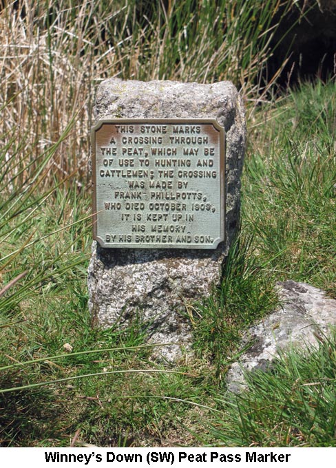
The head water for the Prison Leat is taken off the River Walkham a short distance to the northwest of where it combines with the Spriddle Lake. It was necessary to start at this higher point in order to give it sufficient height to maintain the flow of water all the way to the Prison in Princetown. The leat also merges with the Spriddle Lake, to receive a supplementary supply of water, before continuing its southward journey. The leat skirts to the west of Black Dunghill, east of Great Mis Tor and crosses beneath the B3357, before winding its way down to Princetown and its final destination at the Prison. The Leat was built by the prisoners themselves but, unfortunately, it no longer seems to be maintained with the result that many breaches have occurred and the majority of the water received at its headweir is now lost back into the River Walkham. The lower reaches of the leat are normally almost dry, except during periods of exceptionally heavy rainfall. (Sources: Hemery's 'High Dartmoor', page 1039). 2) Timber Bridge (SX5745/7917) Timber Bridge was originally made of wood and spans the Prison Leat a short distance to the east of Sandy Ford, the point at which the Lych Way crosses the River Walkham. The old wooden bridge has since been replaced by a fine arched stone bridge over the leat. This type of structure is very rare on Dartmoor as the majority of stone bridges, away from the roads, have been built as clapper bridges. In addition to being used for travellers along the Lych Way, the bridge was also vital to the Peat Cutters who worked their extensive peat ties on Maiden Hill between this bridge and Walkham Head. The Peat Cutters created a well-defined cart track northwards from the bridge to their peat ties in the Walkham Head area in order that the peat turves could be transported off the moor. (Sources: Hemery's 'High Dartmoor', page 1019). 3) Walkham Head Peat Pass (SX5779/8138 to SX5785/8149) For information on the Phillpotts Peat Passes and the Marker Stones, please refer to the research notes for the Winney's Down Peat Pass in June 2015. Unfortunately, the metal plaque that was attached to the Walkham Head southern marker stone is now missing, but the one on the northern post is still in place at the time of this walk. (Source: Maurice).
|
| August 2015 (1) - Princetown |
|
1) Black Tor Double Stone Row
(SX5699/7139) This double stone row now supports the outer cornditch wall of Stanlake Farm Newtake. The western of the two rows aligns with the outer face of the Newtake Wall, where a few orthostats can still be seen embedded into the wall. The eastern row has now been almost totally obliterated by the sloping bank of the collapsed wall. Even before the Newtake wall was built, a tinners' leat crossed the stone rows and would have caused quite a bit of damage to it. The leat itself has now all but disappeared. Originally, the stone rows were thought to start at a cairn at the southern end and run for a distance of 295 metres to a large blocking stone, between the rows, at the northern end. The distance between the rows increased from 1.7 metres at the cairn to 2.4 metres at the blocking stone. (Source: Jeremy Butler's 'Dartmoor Atlas of Antiquities - Volume 3', pages 47/49). 2) Thomas
Tyrwhitt and the Princetown Railway (Dousland SX539/681 to Princetown
SX588/735) It is considered that
without Thomas Tyrwhitt Princetown would never have existed. He was amongst
those who were called ‘improvers’. Aged 23, he began operations on
Dartmoor in 1783, completing his Tor Royal residence in 1798. Tyrwhitt was
an MP from 1796 to 1812, at which point he became Gentleman Usher of the
Black Rod and private secretary (and close friend) to the Prince of
Wales. He’d persuaded the Government to build a prison for French
PoW’s. Thus Dartmoor Prison had its foundations laid in 1806 and from 1812
to 1816 housed French and American POWs. After the cessation of hostilities
Princetown declined towards desolation. Resigning Parliamentary duties he
returned to Dartmoor and renewed his activities on behalf of the people.
Tyrwhitt had a vision of developing, cultivating and populating the district
by improving the lives of orphans, paupers and the industrious poor; making
use of the redundant prison in the process. However, his scheme never came
to fruition and was abandoned in 1822. Meanwhile, he’d put
forward a proposal in 1818 for a railway from Plymouth to Princetown. This
became the horse drawn Plymouth & Dartmoor Railway Co, running from a
point near Laira to King's Tor (a temporary terminus). Opened on 26th
September 1823, it would be December 1826 before the railway finally reached
Princetown. Needless to say its total estimated cost of just under £40,000
proved hopelessly short to the tune of an additional £26,000. Tyrwhitt
never lived to see the fulfilment of his lifelong ambition as he died in
1833. Movement of granite from
the quarries of Ingra, Swell and Foggin Tors increased between 1830 and
1840, but later declined. Between 1847 and 1852 the South Devon Railway Co
and South Devon & Tavistock Co purchased lower sections of the original
route for development. In 1877 the GWR, now in possession of the SD&T,
proposed connecting Princetown to the existing Plymouth & Tavistock
Railway, but later withdrew their idea in favour of purchasing the Plymouth
& Dartmoor Railway Co route from Princetown to Yelverton under a new
company known as the Princetown Railway Co. Opened on 11 August 1883 the
upgraded branch was worked in perpetuity by the GWR until nationalisation.
From Yelverton the railway had a 10½
mile run to Princetown with platforms at Dousland, Burrator Halt, Ingra Tor
Halt and King Tor Halt. Over that distance it rose 895 feet and deviated at
least twice from the original route: Yes Tor Bottom and Little King Tor -
where both original track alignments are still clearly visible. The former
terminus in Princetown was in a yard behind what was once known as the
Devil’s Elbow Inn before the GWR relocated their new station to land where
Princetown’s Fire Station now stands. In 1908 William Duke,
who opened Merrivale Quarry in 1876, applied for a light railway order to
connect Merrivale to the Princetown Branch near where the Swell Tor Siding
started. Although the request was sanctioned, and apart from commencing an
embankment which extends from the quarry towards the River Walkham, the work
was never carried out. Passenger traffic declined after 1931 with goods,
minerals and parcel traffic sharing a similar fate by 1937/1938 at which
time the quarries were non-producing. By 1955 passenger and goods traffic
had dwindled to virtually vanishing point, categorising the route as
unremunerative under BR’s reorganisation and modernisation plan. The line
managed to remain open until 3 March 1956 after which its infrastructure was
removed leaving what can be seen today. (Sources: G H Anthony
‘The Tavistock Launceston and Princetown Railways’, Wm Crossing's
‘Princetown – Its Rise and Progress’ & Kath Brewer's ‘The
Railways, Quarries and Cottages of Foggintor’) 3) Clay Works Boundary Stone CW 2
(SX5515/7388)
|
| July 2015 - Merrivale |
|
1) Grimstone & Sortridge Leat (SX540/748 to SX515/717) The Leat was thought to have been built around the 15/16th Centuries to provide a drinking water source for the Manors of Grimstone (SX516/705) and Sortridge (SX506/710) in the parish of Horrabridge. The source of water for the Grimstone and Sortridge Leat is provided by the west bank of the River Walkham (SX552/773). After flowing through a channel under the B3357 at Merrivale, the leat winds around to the west and crosses over the Beckamoor Brook on a wooden launder (SX5356/7493). This launder has the name 'John Wills 1953-1987' engraved into its upper edge. The leat passes the Blacksmith's Shop (SX5361/7477) on Barn Hill, Beckamoor Cross (SX5344/7429) and continues on over Plaster Down. Along this stretch are at least 3 Bulls-eye Stones, which are strategically placed to restrict the flow of water at junctions. The stones have a 1" diameter hole drilled through them to allow a measured amount of water to be diverted along a channel to other farmsteads along the route. The constant flow of water over many years seems to have enlarged the holes and it can be seen on the stone at Grid Ref: SX5269/7323 that the original hole has been plugged and a new one drilled beside it. Both manors are now served by a mains water supply, but the leat still supplies water to large drinking troughs in their farmyards for general use. (Source: Eric Hemery's 'Walking the Dartmoor Waterways'). 2) Blacksmith's Shop - Barn Hill (SX5361/7477) The Blacksmith's Shop, beside the Grimstone and Sortridge Leat, on Barn Hill operated as a Smithy for Quarrymen during the latter years of the 19th Century. The Smithy was used for making, repairing and sharpening the tools used for the extensive stone working industry in the area. In the main, this would have been before the opening of Duke's Quarry at Merrivale in 1876. Before the quarry, the men would work amongst the stone on the hillside, mainly around the slopes of the Staple Tors. The stone would be 'dressed' at Sett Makers Bankers and carted off for sale from the site. On the bank of the leat, below the Blacksmith's Shop, is an excellent example of a Wheelwright's Stone. This would have been used to hold a wooden cartwheel in place while a heated iron tyre was placed over it and hammered into place. (Source: Eric Hemery's 'High Dartmoor' pages 1011 & 1044 and John Hayward's 'Dartmoor 365' page 222). 3) Beckamoor Cross (Windy Post) (SX5344/7429) Information about the Beckamoor Cross can be found on our Dartmoor Crosses website. (Source: Maurice). 4) Sampford Spiney (SX534/724) The moorland parish of Sampford Spiney (Spanley) was included amongst the vills of the west quarter and belonged to Plympton Priory. The church (St. Mary) was probably a 14th-century cruciform building, enlarged to its present size in the early 16th-century. Hall Farm, beside the church, was the manor house. It was rebuilt in 1607 and is a good example of its kind. The whole scene is remote and boulder-strewn. Easton Town (SX535/728) is a 17th-century farmhouse, and behind it is Warne's Kitchen, c. 1600 in date, one of the best examples to be found of the old Dartmoor type of farmhouse in which there was direct communication between the living-room and the cattle-shippen. It retains its primitive porch and original circular stone staircase in a curious "turret." Woodtown (SX539/718), in the picturesque valley of the Walkham, is a 17th-century farmhouse. Huckworthy bridge over the Walkham is of uncertain age. (Source: W.G. Hoskins 'A New Survey of England – Devon’). Information about the Sampford Spiney Cross on the village green can be found on our Dartmoor Crosses website. (Source: Maurice).
The dressed granite block beside the track at Heckwood Tor is a stone that was intended for use in building the breakwater at Plymouth, but was abandoned after a flaw was found in the stone. A substantial amount of granite used in the building of the Plymouth Breakwater was sourced from the Quarry at Heckwood Tor. The dressed stones were carted from the Quarry down to Morwellham Quay and then loaded onto barges for transportation down the Tamar to their destination in Plymouth. (Source: Eric Hemery's 'High Dartmoor' page 1007).
|
| June 2015 - Fernworthy Forest |
|
1) Starkey's Bridge & Memorial Stone
(SX6400/8464) Information about Starkey's Bridge and Memorial Stone can be found on our Dartmoor Crosses website. (Source: Maurice). 2) Teignhead Farm (Grid Ref: SX635/843) Please follow the attached link to the notes made on Teignhead Farm from our previous visit in July 2013. 3) Winney's Down Peat Pass (SX6186/8230 to SX6208/8250)
4) Sittaford Stone Circle (SX6301/8281) This Stone Circle, which consists of about 30 recumbent stones, was discovered back in 2007 by Alan Endacott during a period of swaling in the area. It wasn't until this year (2015) that funds became available and the 'Moor than meets the Eye' project commissioned a geophysical survey of the area. This, together with an analysis of soil samples taken from beneath the stones, established that they have been in place for around 4,000 years, which dates the circle to around the same time as Stonehenge! The stone circle, at 525 metres above sea level, is not only the highest on Dartmoor, but the highest in the whole of Southern England. With a diameter of 34 metres, it is the second largest on the moor, beaten only by the circle on Mardon Down, near Moretonhampstead, which is about 38 metres in diameter. It is also the first stone circle to have been discovered on Dartmoor in over 100 years. Not all the stones are intact as some have become broken over the years, but the fact that a number of 'packing' stones have also been found in the holes strongly suggests that the stone circle originally stood erect. (Source: various internet sites).
|
| May 2015 - Bennet's Cross |
|
1) Bennet's Cross (SX6801/8163) Information about Bennet's Cross can be found on our Dartmoor Crosses website. (Source: Maurice). 2) Blue Jug (SX7084/8036) & Gray Weather (SX7068/8031) Boundary Stones
3) Stoneslade Metal Cross (Grid reference witheld)) Information about the Stoneslade Metal Cross can be found on our Dartmoor Crosses website. (Source: Maurice). 4) Herring's (Aaron's) Knock (SX7088/7811)
Another possibility for the name of Herring's Knock is that it has derived from 'Heron's Cnoc', which translates as the 'Hill of the Heron'. 'Cnoc' is Gaelic for Hill and it's easy to see how the word 'Heron' has been transmuted into 'Herring' over the generations. A third possibility that has been suggested is that the 'Knock' resembles the notch made in the end of arrows used in Archery into which fits the bowstring, as this is also referred to as a 'Knock'. (Source: Dave Brewer's 'Dartmoor Boundary Stones' pages 80/81 & Legendary Dartmoor Website). 5) Gatepost in Lane near Lower Blackaton (SX6986/7783) The Gatepost in the lane leading down from Hameldown to the road at Lower Blackaton had an interesting round hole drilled well into the post very near the top. Although I'm unable to find anything written about this stone, I believe it was once what was known as a 'Holed-Stone' gate hanger. This worked by having two stones, with holes drilled into them, acting as a pivot for the gate. One stone would be laid flat on the ground, with the hole facing upward, and mostly built into the stone wall beside the gateway. The other would be laid flat on top of the wall, with the hole facing downward and overhanging the edge of the wall. The upright pillar of the gate, on what would be the 'hinged' side, would be extended above and below the bars of the gate and these extensions would fit into each of the holes. Thus the gate would be able to swivel open and shut. This stone was probably removed from its original position and has now been reused as a modern upright gatepost. (Source: Thurlow's 'Dartmoor Companion' pages 230-235 & Maurice's Theory).
|
| April 2015 - Meldon Reservoir Car Park |
|
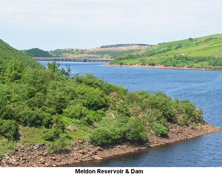
1) Meldon Reservoir (Dam: SX562/916)
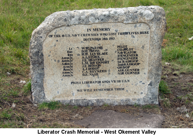
2) Dinger Tor (SX5865/8815) Legend has it that Dinger Tor is the original home of Devon Cream Teas. At one time a local giant had four wives, of which the eldest three were very mean and ill-tempered, unlike the kind and loving younger wife who was always the giant's favourite. The three older wives were very jealous and decided to make their husband's life a misery until he got rid of her. In the end he relented and took the younger wife to the coast where he found her a safe and secure place to live in a cave. One day, only the brave action taken by the young girl prevented a ship from being lured onto rocks by a group of local wreckers. In order to express his thanks, the ship's captain showed the girl how to prepare a 'real' cream tea. On his next visit to see her, she made a cream tea for her husband, the Giant. He was so delighted with this treat that he decided to over-rule the wishes of his other wives and bring her back home. They too were so overcome by the taste of this treat that their whole nature changed and all four wives decided to work together to set up a Cream Tea Cafe at Dinger Tor. Sadly, this is no longer open for business! (Source: John Hayward's 'Dartmoor 365', page 61). 3) Liberator Crash Site - West Okement Ravine (SX565/884)
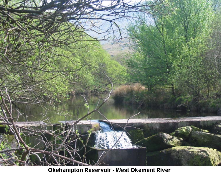
On 28th December 1943, USN Fleet Air Wing 7, based at Dunkeswell in Devon, despatched the Liberator, together with fourteen others, on a mission to locate and attack a group of enemy destroyers in the Bay of Biscay. During the patrol PB4Y-1 B-5 engaged with two enemy aircraft and a second Liberator, PB4Y-1 B-12, being close by joined fire at which the enemy were forced to break off their attack, disappearing into cloud. Upon concluding their patrol these two PB4Y-1s exchanged base headings and returned home individually. On reaching England’s south-west coast PB4Y-1 B-5 descended into cloud and having turned onto an easterly track, struck the hilltop, digging a furrow ¼ mile long, before dropping 400 feet onto the rocky ground of the West Okement Valley, where it blew up, disintegrated and burned out. All ten crew were killed. Some reports suggest the aircraft’s remains were strewn over a quarter of a mile. Investigations revealed that the Liberator had crashed with its full bomb complement. Apart from encountering some harsh winter weather conditions in the vicinity the cause of the crash remains a mystery; the pilot, Lt. William W. Parish, was one of the most experienced in the squadron. This was the fourth American plane to crash on Dartmoor during the month of December 1943. It would seem that back in the 1960s a considerable amount of wreckage was still in-situ and complaints from various Dartmoor conservationists caused the site to be cleaned up. One of the Pratt and Whitney engines was restored to working order. (Refs: Wotherspoon, Clarke & Sheldon and Legendary Dartmoor). A scanned copy of Graham Lewis's pages on the Liberator Crash can be found here, as a .pdf file. 4) NDWB (North Devon Water Board) Reservoir (SX560/898)
|
| March 2015 - Car Park west of Whiteworks |
|
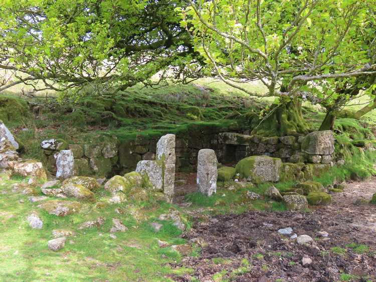
1) Devonport Leat The expansion of the dockyard at Plymouth encouraged the growth of a new town – Devonport - and, as a consequence, a rivalry between it and Plymouth. To obtain a copious and independent water supply for this new town powers were obtained in 1793 to take same from the West Dart, Cowsic and Blackabrook resulting in a leat 21¼ miles long. Today that leat only carries water to a point near Burrator dam from where it is piped to the Dousland treatment works with any surplus flowing into the reservoir. The Plymouth, or Drake’s, leat was a separate undertaking dating from 1585 and abstracted water from the Meavy at a take-off point below Lower Lowery. The first tunnel at Nuns Cross utilised the linking together of several existing adits from Nuns Cross Mine but this resulted in a sluggish flow which was remedied by a new, lower sited channel and tunnel c1850. (Source: Hemery). 2) Old Farm Hut (SX6016/6991)
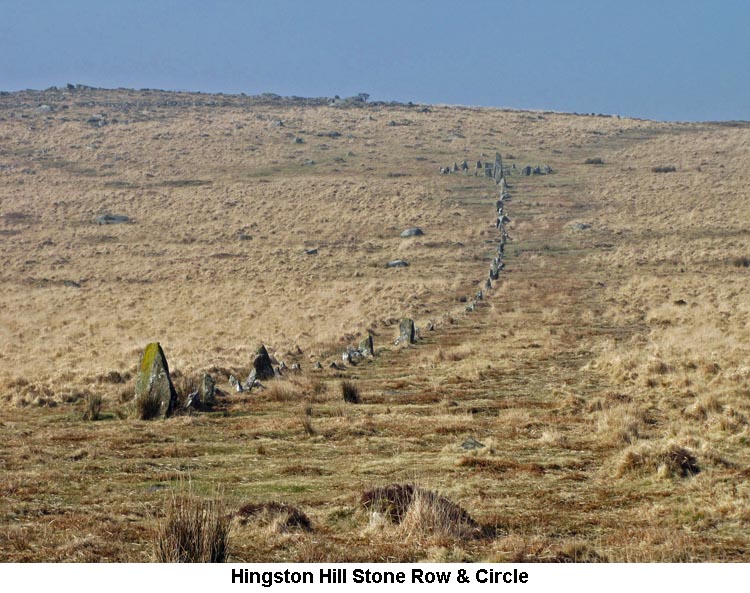
A former occupant of Nun's Cross Farm, Mrs Phillips, always referred to the building by the name of 'Old Farm'. (Source: Eric Hemery's 'High Dartmoor' & 'Walking the Dartmoor Waterways'). 3) Devonport Leat (Hutchinson) Cross (SX5995/6991) Information about Devonport Leat Cross can be found on our Dartmoor Crosses website. (Source: Maurice). 4) Hingston Hill Stone Row (SX5902/6938 to SX5869/6927)
5) Deancombe Farm Staddles (SX5798/6877 & SX5797/6878) At Deancombe Farm there are two sets of Staddles to be found amongst the ruins of the farmyard buildings. Staddles are normally mushroom shaped stones which stand about 12 to 18 inches above ground and which are set in two or three regular rows to form a rectangle. The farm's supply of hay would be stacked on top of these Staddles in order to keep it off the ground. This would ensure that the bottom of the stack stayed dry and would also be out of reach of any rodents who might want to feast on it or make their nests in it. The Staddles at Deancombe have now lost their mushroom-shaped caps, but still provide a good example of how they would have been used back in the time when it was a working farm. (Source: Maurice).
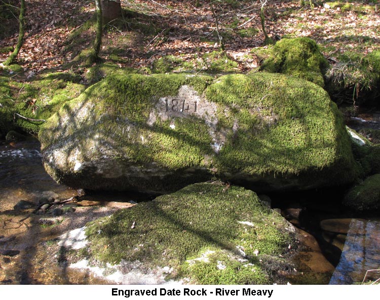
This rock, which is in the bed of the River Meavy just above Norsworthy Bridge, is clearly engraved with the year '1841'. I've not been able to discover anything about the rock or the reason for the engraving. I can therefore only assume that perhaps that the rock was moved downstream by floodwater (no mean feat due to it's size and weight) in that year and has been engraved accordingly. There is a precedent for this with a rock in the River Cowsic which is engraved: 'This Stone was Moved by a Flood 1707'. (Source: Maurice). 7) Indian's Head (Devonport Leat) (SX5724/7131)
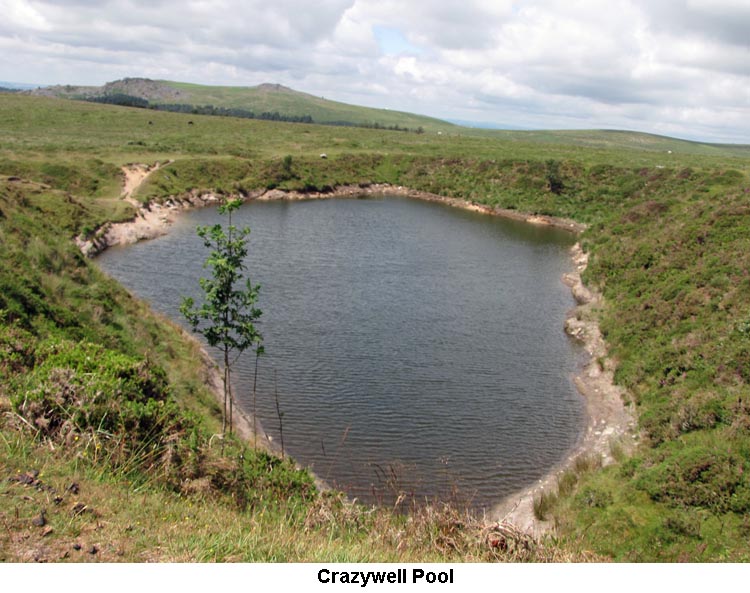
8) Crazywell [Classenwell/Classiwell/Clazeywell] Pool (SX582/704)
There are legends and folklore tales attached to it, such as the howling of tormented spirits or the foretelling of parishioners’ deaths. There was an old tradition that Piers Galveston once concealed himself on the moor during a period of court banishment and that a local Reverend, with poetic licence, penned a ballad in which Piers meets the local Witch of Sheepstor at the poolside to ascertain his future which led to a misreading and his subsequent beheading. Also, that visiting the pool on the night of Midsummer’s Eve will result in dire consequences. The pool was also used for military training purposes and in 1998 a young marine tragically drowned there whilst on an exercise. (Source: Butler, Crossing, Hemery, Legendary Dartmoor, Rowe and Worth).
|
| February 2015 - Haytor Lower Car Park |
|
1) Hey Tor Granite Tramway There were leased quarries on Hey Tor Down circa 1819 at which time granite was conveyed off the moor by horse drawn wagon; a costly and time consuming task. To alleviate such expense a tramway (brain child of George Templer, quarry lessee and son of James Templer the canal builder) was opened in September 1820. Its total length from Emsworthy Rocks to the Teigngrace Canal Terminus was about 10½ miles and in traversing that distance it dropped over 1,200 feet in altitude. At the time of the tramway’s inception the acquisition of metal rails was both unreliable and costly so the idea was germinated of utilizing quarry material. Granite was hewn into blocks about 1 foot square and between 4 and 8 feet in length and then worked along one long edge to create a rebate 7½ inches wide by 3 inches deep. A pair of blocks would then be laid on the ground with their wider rebate outer most and facing up to provide a surface for wagons to run along. The gauge between the granite ‘rails’ was set by laying each pair so that the shoulders of the shallower cut were maintained at a distance of approximately 4 feet 3 inches apart. These raised shoulders thus enabled wagons with four 2 feet diameter flangeless iron wheels to follow the course of the track without falling off; each flat topped, side-less, wagon being capable of carrying a maximum load of 3 tons. Six tramway branches were laid on the downs: Emsworthy Rocks East and West, Holwell Tor, a Rubble Heap north-west of Hey Tor, and two for Hey Tor itself. The ¾ mile branch to the north side of Holwell Tor (also known as Ovals Tor) connected the lowest and second largest quarry of the Hey Tor group to the main line. Transporting hewn granite out of this location was by necessity a stiff task. From here a train consisting of twelve coupled wagons – some 36 tons or more in weight – would see a team comprised of eighteen or nineteen shire horses hauling the load up to the main line for onward movement by less energetic means. Two rhymes come to hand: 1) Nineteen stout horses it was known
From Holwell Quarry drew the stone,
And mounted on a twelve wheeled car
'Twas safely brought from Holwell Tor.
2) Eighteen brave steed and twelve old car
To take stone from Ovals Tor;
The stallion in front they did place
It was John Murrin's, of Teigngrace.
Although there had been a pause in its use, around 1841, the enterprise worked until about 1858 when disharmony and lost contracts took hold and the tramway fell into disuse. There was some sporadic use into the 1860’s but competition from Cornish quarries and other sources brought about its demise. Granite from the quarries was incorporated in the construction of London Bridge and other buildings in the capital including the British Museum library. The last occasion on which Hey Tor granite was sought was in 1919 when stone for Exeter’s war memorial in Northernhay Gardens was cut. The moorland section of the granite tramway is now protected as a Scheduled Ancient Monument and has the distinction of being the first ‘rail’ line constructed in Devon. (Source: Jeremy Butler, William Crossing, Helen Harris, Eric Hemery and Legendary Dartmoor). 2) Quarrymen's Hut - Holwell Tor (SX/7507/7778) This is a fine example of a bee-hive hut, which can be found hidden below the level of the tramway. There are several suggestions as to it's original purpose: a workman's shelter, a tool store, or possibly an explosives store. The latter seems more logical as you would not fit many workmen inside and the large roof slabs do suggest a need for something to contain an explosion should it have happened. (Source: Legendary Dartmoor website). 3) Becka Brook (new) Clapper Bridge (SX7477/7788)
During our December 2021 walk, we saw that a plaque has now been added to the side of the bridge to confirm that the bridge was erected in 2014 by the Dartmoor National Park Authority. The plaque also acknowledges that the bridge was funded by HF Holidays Ltd and the Moorland Ramblers Group. (Updated: December 2021).
4) Widecombe Church (SX718/767)
Widecombe acquired considerable fame or notoriety in the mid-seventeenth
century because of the terrible storm which hit the village in autumn 1638.
News of the events quickly spread through England and within a week or so of
the storm, a pamphlet describing ‘those most strange and lamentable
accidents’ was published in London. It quickly sold out and a second, larger
account was produced. Together, they provide a graphic and at times gory
description of the events which occurred in Widecombe on Sunday 21st October
1638, during divine service, as allegedly recounted by eye-witnesses who had
‘now come to London’.
5) Shovel Stone (SX/7342/7632) This boundary rock lies about 350 yards to the north east of Hollow Tor. Although there is no inscription on the rock, it marks the boundary between the Parish of Widecombe and the Manors of Dunstone with Blackslade. (Source: Dave Brewer's 'Dartmoor Boundary Markers' pages 81/2).
|
| January 2015 - Castle Drogo Entrance |
|
1) Castle Drogo Hydro-Electric Station (SX724/898) At the time that Catle Drogo was built, in the early 20th Century, it had no access to the mains electricity supply. A high quality hydro-electricity generation system was installed in the 1920s and operated until 1994, even though the castle was connected to the National Grid in the 1950's. The hydro-electricity system is situated in a particularly beautiful part of the River Teign Valley, next to the famous deer park wall. This Lutyen's designed Turbine House is now Grade II listed. The turbine is currently in a severe state of disrepair but could be restored by the original manufacturer, Gilbert Gilkes & Co., to make it fully operational again. Once restored it has the potential to supply the equivalent of all the onsite electricity needs and even produce surplus for export to the National Grid. (Source: National Trust website). 2) Granite Stone Sculpture - River Teign (SX7102/8904)
|