|
|
|
|
|
|
|
|
|
Research Notes 2022
| November 2022 - Rees Jeffreys Car Park - Merrivale |
| 1)
Rees Jeffreys Car Park - Merrivale - (SX5400/7503)
William Rees Jeffreys (1871 to 1954) was born in London, the eldest of four children of William George and Mary Ann (nee Garratt) Jeffreys. He was privately educated and, in 1891, joined the Board of Trade as a clerk in their Commercial, Labour and Statistical Department. He was also a keen cyclist and joined the Cyclists' Touring Club, where he toured Scotland and Ireland as well as his native England. He was very keen on the British road system, becoming a key figure in the UK highways system. Later, he became Honorary Secretary, and then the Chairman, of the Roads Improvement Association. He was an early advocate for a ring road around London and helped instigate the British road numbering system. In 1937 Jeffreys was described by former UK Prime Minister David Lloyd George as "the greatest authority on roads in the United Kingdom and one of the greatest in the whole world."
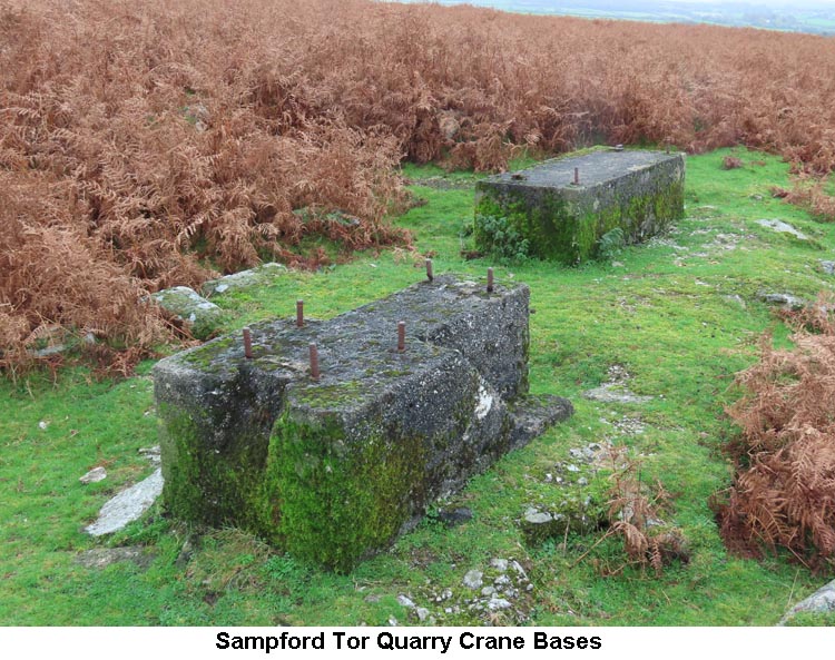
2)Grimstone & Sortridge Leat (SX540/748 to SX515/717) Details of this, well maintained, Grimstone & Sortridge Leat were covered previously on our walk in July 2015. 3) Heckwood Tor Worked Stone - (SX5391/7375) The large rectangular worked stone beside the track at Heckwood Tor was also covered in our walk in July 2015. 4) Sampford Tor Quarry Crane Bases (SX5309/7311)
|
| October 2022 - Burrator Arboretum |
| 1)
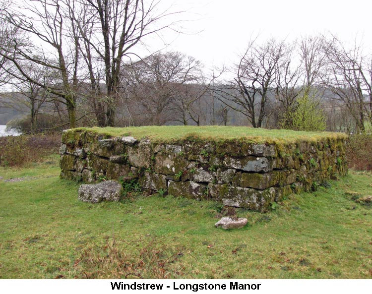
Windstrew (Whittenknowles Rocks) - (SX5858/6715)
|
| July 2022 - Prewley (Sourton) |
| 1)
Sourton Ice Works - (SX546/901)
Notes on the Sourton Ice Works were written up in August 2019, to which two of Bob W's photos from our July 2022 walk have now been added. 2) Sourton Apple Crusher (abandoned) - (SX5464/8960)
Apples would be crushed by pouring them evenly around the trough of the mill stone and a round upright granite stone (wheel), fixed to an axle, would be rolled around the trough by a horse fixed to an harness. Apple mills were not designed to produce a smooth ground pulp, but one where the cellular structure of the fruit was thoroughly broken up. To achieve this, the floor of the trough, and sometimes the tread of the upright wheel, would be corrugated radially. This would ensure that that the wheel would bob up and down, rather than progressing smoothly around its course. This process was known as 'pounding' the apples, rather than 'grinding', and the process was not considered complete until all the pips were found to have been crushed as well. (Source: Richard Hansford Worth 'Worth's Dartmoor' - pages 384 - 386). 3) Iron Catch Gate - Sourton Downs - (SX5446/8951)
There is an interesting story attached to site of Iron Catch Gate. Legend has it that many years ago, the body of a dead man was discovered at this spot which was, of course, on the boundary of the Bridestowe and Okehampton Parishes. Although the body was lying just on the Bridestowe side of the boundary, The commoners of Bridestowe and Sourton refused to give him a proper burial. This led to the parishioners of Okehampton stepping in and arranging for his interment. The parishioners of Okehampton then claimed the piece of land on which the body lay for their own parish. This, in turn, led to years of squabbles between the two sets of parishioners especially during their beating of the bounds. It was not until fairly recent times that Bridestowe have finally come to terms with conceding the boundary line with Okehampton. The piece of land, which is bounded by the King Way and the ancient boundary ditch from Iron Catch Gate to Vellake, on which the body was found is now known as 'The Triangle'. (Sources: Dave Brewer's 'Dartmoor Boundary Markers' - page 174, Eric Hemery's 'High Dartmoor' - page 928, William Crossing's 'Guide to Dartmoor' - page 59 & Jeremy Butler's 'Dartmoor Atlas of Antiquities - Volume 2 - page 224). 4) Flying Fortress Crash Site - Tiger Marsh - (SX5515/8842) On Christmas Day in 1943, a military Boeing B17-G (nicknamed the Flying Fortress) airplane had been on its way back from a meteorological mission off Cornwall to its base, at Cheddington, Buckinghamshire, when it suffered an overheating engine and came in to St Eval, Cornwall, for repairs before continuing its flight. The engine required a new oil filter to be fitted and the plane had to be refuelled. The staff at St Eval offered to put them up overnight so that they could continue on their journey the next day. The only Englishman in the crew, Basil Browne, wanted to take them up on the offer but the other seven crew were American and wanted to get back to their base so that they could enjoy the rest of Christmas Day with their fellow countrymen. The plane took off again at 11.30 and, on reaching Dartmoor, was flying at a height of around 1200 feet. Young Sergeant, Basil Browne, who was sat in the nose of the plane was using his recently acquired map reading skills and noticed that parts of Northern Dartmoor reached heights of around 1800 feet, a good 600 feet above their current height. He sent a message to the pilot, via the navigator but the pilot didn't seem to be too concerned as visibility at that time was quite good. Shortly afterwards, the plane ran into a bank of cloud and, although the Pilot tried to raise the height of the plane, it didn't react quick enough and struck the top of a hill. The impact ruptured the fuel tanks and set the plane on fire. It flew/bounced on for about another ¾ mile before coming to a halt at Tiger Marsh, close to Lyd Head. Of the eight crew members five died in the crash, the Pilot (1 Lt. Ernest Patterson) and the Co-Pilot (2 Lt. Raymond Coats) were able to escape form the crashed plane uninjured, apart from suffering burns. Sergeant Basil Browne, who had been sat in the nose cone, was catapulted out of the plane through the perspex nose and was left unconscious on the ground. He also caught his left arm on something which broke his wrist and ripped his wristwatch clean off his arm. The Pilot and Co-Pilot, despite suffering from their burns, were able to walk off the moor and raise the alarm. Two local men drove up to the crash site in their Jeep to investigate the damage and found the unconscious Basil Browne. They brought him off the moor in their vehicle and, despite the burns and injuries, all three men made a full recovery from the crash. In
1983, some 40 years after the crash, a Mr Hatcher found a watch near the
crash site but just assumed it was lost by another walker on the
moor. It wasn't until 1994, after hearing a radio interview with
Graham Lewis about another crash on Dartmoor that he thought any more
about the watch. Graham Lewis has done a lot of research and
written a book about all the airplane crashes on the moor. Mr
Hatcher made contact with Graham Lewis over the watch he'd found and
Graham agreed to make some investigations. He soon found out that
watch belonged to Basil Browne, who was then a retired School Teacher,
and had several conversations with him about the crash. Although
the watch was loaned to Basil for that There are still a few pieces of wreckage to be found at the site and, until recently, there was a metal plaque, attached to a short stake, which acted as a memorial to the crash and its victims. More recently a fine wooden memorial had also been placed at the site. However, in 2022, a large granite monument has been installed as a more permanent memorial to this tragic accident and the previous two memorials removed. Unfortunately, there is a spelling mistake on this monument as Basil Browne appears to have lost the 'e' off the end of his surname, hopefully a mistake that will soon be corrected. (Source: Graham Lewis's book on Dartmoor Plane Crashes). A scanned copy of Graham Lewis's pages on the Flying Fortress Crash can be found here, as a .pdf file (Please ignore pages 122 & 129). 5) Liberator Crash Site - West Okement Valley - (Memorial - SX5656/8832) Details of the Liberator airplane crash are covered in the Research Notes for April 2015, to which a photo of the recently erected granite monument has now been added.
|
| June 2022 - Sharpitor |
| 1)
Leather Tor Metal Cross - (Grid Reference withheld)
Information about the Leather Tor Metal Cross can be found on our Dartmoor Crosses website. (Due to the fact that other similar crosses on the moor have been either stolen or damaged, we have decided not to publish the exact location of this cross).
|
| May 2022 - Two Bridges Quarry |
| 1)
Traveller's Ford Metal Cross - (Grid Reference withheld)
Information about the Traveller's Ford Metal Cross can be found on our Dartmoor Crosses website. (Due to the fact that other similar crosses on the moor have been either stolen or damaged, we have decided not to publish the exact location of this cross).
|
| April 2022 - Bennet's Cross |
| 1)
Challacombe Farm & Medieval Village - (SX6934/7952)
There has been a continuous settlement on Challacombe Down since at least the Bronze Age, 3,500 years ago. At this time, the main settlement was probably based at Grimspound, but they would also have farmed the land on the other side of the West Webburn, on Challacombe Down. The animals were taken out into the fields to graze by day and brought back into the pound at night to keep them safe from prowling wolves and bears. In later times, a medieval settlement was built at Challacombe and evidence can still be clearly seen of the lynchettes (small strip fields) running down the valley sides.
Challacombe Farm is now owned by the Duchy of Cornwall and is run organically to conserve and enhance its archaeology and wildlife. The cattle, Welsh Black and North Devon, have been chosen for the way they graze with a ripping action which not only enables them to graze the boggy rhôs pasture in the valley bottoms but allows wild flowers, like orchids, to thrive in this type of pasture. The sheep, Shetland crossed with Icelandic Rams, are light on their feet and nibble the grass down tight. They are also very good at keeping the gorse under control which helps a number of different species as well as protecting the archaeology. The livestock are out on the grass all the year around, but are able to come inside during really bad weather during the winter, when their diet is supplemented with hay harvested from the flower-rich meadows during the summer months. The farm has twice won the Duke of Cornwall's Habitat Award Scheme, in 1996 and 2005. The farm welcomes visitors and allows walkers to roam anywhere on their land to the western side of the road. (Sources: Hemery's 'High Dartmoor' pages 639-642 & three signboards distributed around the farm).
|
| January 2022 - Princetown |
| 1)
Rundlestone - (SX5741/7497)
Although on the Royal
Forest of Dartmoor boundary line (between Ysfothere - North Hisworthy/Hessary
and the middle of Mystmore - Great Mis Tor) the Perambulations of 1240
and 1609 do not mention Rundlestone. Also recorded as Rendlestone the
name appeared for “a great stone called Roundle” in 1675 and as
“Rundle Stone/Rundlestone” in other 18th century references.
RH Worth attributed a large boulder (roundel) on Rundlestone Tor
(situated on the “Forest” boundary) as bearing the title, it having
two unique rock basins. Wm Crossing (and Hemery), however, link it to a
boundary stone that was recognised in 1702 and sited on the south side
of the Tavistock road near the two cottages that face one another. The
demise of “Crossing’s” stone began with its use as a gatepost,
then to be seen lying on the ground and disappearing after 1881; the
belief it was wantonly broken up and used in nearby wall building.
Crossing measured it in the year mentioned as 7 feet in height above its
set stones and 4 feet in girth: on one side near the top the letter R
was cut in relief 7 inches high. It would seem dwellings
appeared near Rundlestone with the development of Princetown at the turn
of the 19th century. A small hamlet formed which Crossing described as
miserable huts, “which the ruins of some still attest”, JLW Page
wrote of them as “somewhat poverty stricken in appearance”. A sketch
map from Kath Brewer for the late 19th century shows the dwellings of
eight families along the stony track leading from Rundlestone towards
New Forest Corner: the remains of Mistor Farm (Mount View on OS maps of
1888-1913) being found at SX5710/7552. South of the Tavistock road near
and below Rundlestone Tor were two dwellings whilst north of Hollow Tor
was a quarry and tin mine named Wheal Lucky (operational between 1797
and 1871). Hemery refers to the remains of “ruined farms” and at a
guess the majority of these unfortunate abodes would have fallen into
disrepair about the turn of the 20th century; those of better quality
remaining today.
2)
Omen Beam Tramroad - (SX5753/7687 to SX5843/7421) The tramroad dates from
1846 when the British Patent Naphtha Company rented the old war prison
infirmary to produce naphtha and other by-products from peat. With
conversion to a retort house a horse-drawn tramroad was also constructed
out to a granite wharf at approximately SX5753/7687 (1.4m high, 12m long
and 5.5m wide) that was connected to Yearlick (Greena) Ball’s turf
ties by packhorse. There is evidence to suggest a branch tramroad went
off eastwards, just south of Fice’s Well, towards a probable wharf in
Long Plantation on Omen Beam linked to other turf ties there. Not far
from the tramroad’s access off the B3357 The
Touchstone is passed on the left. At a cost of £19,000 the
naphtha project only lasted a couple of years as it encountered
production problems and by 1850 the retort house had become the prison
gasworks. Once a gasworks outside the prison walls was opened in 1875
the former infirmary became the convicts’ workshops. (Source:
Eric Hemery, DartmoorCam and heritagegateway.org.uk). 3) Fice's Well - (SX5773/7587) The notes for Fice's Well written up after our August 2013 walk have been updated after further research. 4) Peat Cutting - (No specific Grid Reference) For centuries peat was a
substance valued both domestically and industrially as a fuel. Formed by
the decomposition of plant material in saturated conditions of both
subsoil and atmosphere true peat does not occur everywhere. Wet ground,
moist air and cool temperatures together with decomposing underlying
granite are necessary for its development. The largest area of peat
blanket bog occurs north of the Tavistock to Moretonhampstead road
stretching towards Okehampton. Peat, capable of retaining
a large quantity of water in proportion to the solid material which
forms it, absorbs moisture faster than losing it and necessitates
considerable drying time before use, not easily achieved in the moorland
climate. Although thermally inferior to coal it was indispensable
domestically and from medieval times when converted to charcoal,
essential to the tin industry. For domestic use it was customary
for a “holding” to have its own turf-tie where an occupier had
established appropriation to cut peat, keeping to their own tie and not
interfering with anyone else’s. Cutting occurred between
late April and early September. A long strip called a “journey”,
commonly 40 yards long, would be cut two turves wide and 18 to 20 inches
deep. Successive journeys would be worked parallel with each other with
the turf-tie taking on the form of a rectangular pit. Its depth would
increase to several feet with the general expectation that depth
produced better fuel. A peat tie could be worked for many years, the
excavation extending until the individual’s area was exhausted or its
limit reached. Once peat had been removed care was taken to replace the
top turves to preserve herbage. Specific and very sharp
tools were used. A long wooden handled slitting knife, blade 2½ feet in
length and 3 to 4 inches broad to firstly trim the edge of the previous
year’s cut before the new season’s work could begin and then to make
an initial deep cut into the peat 14 inches from and parallel to the
previous year’s edge along the length of the journey. The covering
layer of soil and vegetation was then removed, this could be up to 2
feet in depth, with the use of a budding-iron (a flat triangular pointed
shovel) whilst standing within the turf-tie. The tool was pushed
horizontally into the trimmed face to reach the initial cut so as to
lift the top layer away and cast it into the tie for replacement once
the journey was finished. Next the actual task of
peat cutting commenced using the turf-iron. This had a blade 7 inches
wide with one side formed into an angle of 90 degrees and having a
curved cutting edge. It had a socket to take a handle and “shoulder”
on which to apply foot pressure for pushing down into the peat. Cuts
were made at a slightly slanting angle at two inch intervals working
backwards along the journey to produce two turves that were 20in x 7in x
2in, one turve being cast into the previously worked tie whilst the
other went onto the uncut ground above. Direction being dependent on
whether the worker was left or right handed. It was said that an
industrious worker could cut two such journeys in a day! Once cut, the turves were stood up against one another in pairs to facilitate drying. The longer they’d take to dry might involve them being made into small piles called stooks. Once suitably dry they’d be taken to their place of use and if on a farm made into a rick and thatched. A prolonged spell of wetness could render the turves useless. Peat cutting for industrial and/or commercial purposes led to larger turves being cut and journeys of greater area worked. (Source: Wm Crossing and Helen Harris).
|


.jpg)
.jpg)